|
|
|
| See Homepage. | This page: Read about a range of motorist & cyclist maps offered by Bartholomew's in the late 1920s. |
"A Bartholomew Map My Guide".
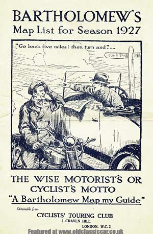
The cover shows a fine illustration of a helpful chap sat in a 1920s tourer, giving directions, from his Bartholomew's map naturally, to a slightly frazzled looking motorcyclist. Note the motorcyclist's attire, a common sight back in the vintage days - leather gauntlets, long warm overcoat, and a non-too-sturdy looking flat cap, to keep his cranium warm albeit somewhat un-protected in the event of mishap. Turn the page and the eager reader is welcomed to the works of Messrs Bartholomew's Geographical Institute, ".. specially planned for the development of their particular class of work, equipped with the finest machinery and the latest appliances calculated to aid in perfecting the various processes of Drawing, Engraving, Lithographing, and Printing of Atlases, Maps, Plans, and ever kind of Cartographical work", the staff of whom worked under the supervision of Mr John Bartholomew, F.R.S.E., F.R.G.S., Cartographer to the King. With that out of the way, the various maps are now introduced, along with glowing recommendation from a number of happy purchasers. For instance, the "Half Inch to Mile" map of England and Wales has already met with approval from the motoring masses, for instance some quotes from the leaflet - "As a motorist one tries many maps, but always comes back to the matured opinion that Bartholomew's are the Best" "No one who has any knowledge of the productions of the various firms who issue Road Maps can have the slightest hesitation in preferring Bartholomew's" In addition to the usual maps of the British Isles, there are also specific maps for Scotland, England, Ireland and Wales, plus Geological maps, district maps and more, plus pocket atlases for many foreign destinations. The special motoring maps are of most interest though, with quite a selection on offer, including contour maps not only for the UK, but also Europe and one of India, still part of Empire of course. The back cover contains encouraging snippets taken from various publications, a few of which are motor-related: The Autocar - "The smallest names are easily and clearly read, and in this respect Messrs Bartholomew set an example which might be followed with profit by many other map producers". Motor News - "It is almost a work of supererogation to say anything in favour of the Excellent Maps issued by this Eminent Firm. Nothing better has ever been published." Return to the motoring collectables page for more unusual items that relate to motoring in some way. |
|
|

Custom Search
|
 |
| Old Classic Car (C) R. Jones 2026. Content not to be reproduced elsewhere. |
| Website by ableweb. |
| Privacy Policy, Cookies & Disclaimers |